Drone photogrammetry
Drone photogrammetry is a high tech process for extracting georeferenced information from aerial images captured with precise positioning (RTK/PPK).
By combining multiple images with a high percentage of overlap, accurate orthophoto maps, 3d models, digital terrain models (dtm/dsm),
volume and area measurements, and others are constructed.
Aerial mapping
The service is performed by aerial photography of the site with drones equipped with high quality cameras and navigation systems, which capture every detail with high precision and clarity. By using GCP (Ground Control Points) and/or RTK/PPK technologies, georeferenced accuracy suitable for engineering, geodesic, and GIS applications is guaranteed. The collected footage is processed with specialized and advanced software.
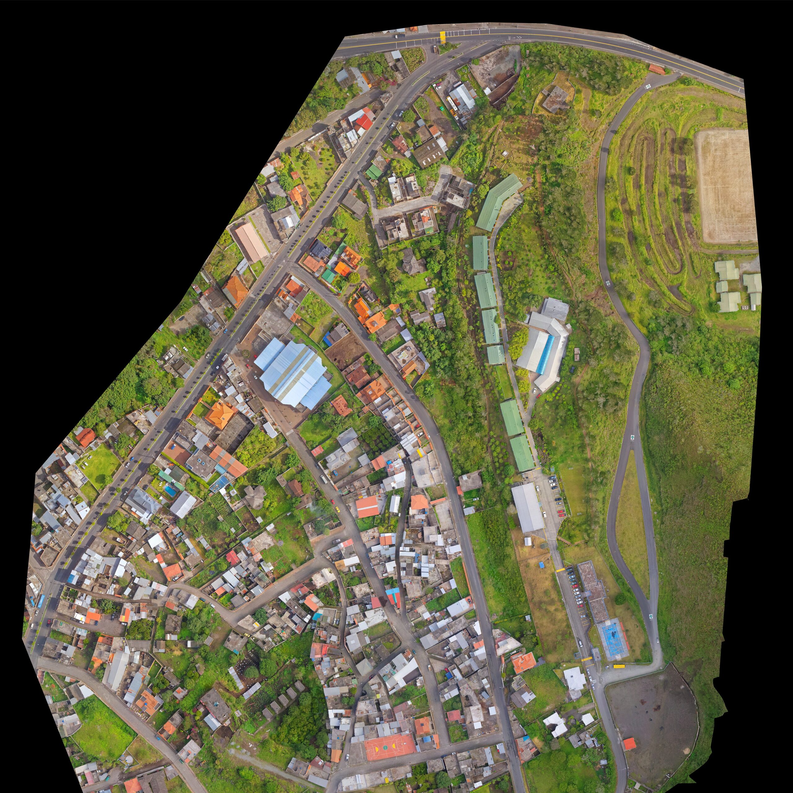
2D orthophoto maps
Georeferenced images with high resolution that provide a clear and uniform view of the entire captured area. they are suitable for cadastre, planning, monitoring construction progress, and gis analyses.
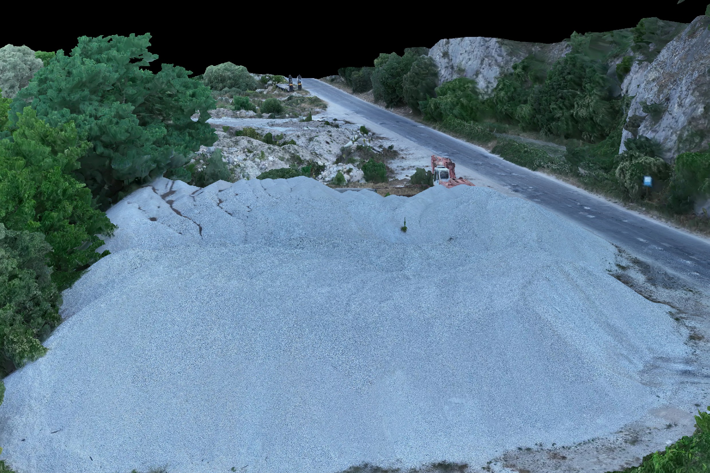
3D models
Photorealistic three-dimensional visualizations and point clouds that offer a realistic and in depth view of objects or terrains from any angle. models for measurements, volumes, profiles, and visual control are supported.
Construction
The application of drone photogrammetry in construction is a precise method for measurement and analysis that supports construction processes at every stage - from design to the completion of the site. High accuracy aerial data allows for effective progress tracking, resource optimization, and quality control.
Monitoring and analysis
Drones create detailed 2D and 3D models, through which accurate control of excavation work, embankments, volumes, and profiles is performed. This facilitates the comparison of the actual execution with the project documentation and supports timely decision making.
Tracking progress
Regular aerial photography provides a clear and up to date view of the construction site's development. The obtained data supports communication between investors, engineers, and contractors, ensuring transparency and accuracy at every stage of the construction process.
Technical applications

Earthworks calculations (cut/fill)
Monitoring and documentation of construction progress
Infrastructure planning and surveying
Mapping and analysis of agricultural areas
Geodetic and topographic surveys
Integration into BIM and reconstruction projects
Digitalization and damage assessment during disasters
Legal and cadastral purposes
Preservation of cultural heritage
Advertising, property sales, and tourism
Detailed examination of complex terrains
Training and visualization
Benefits compared to satellite images and other methods
Drone photogrammetry offers significant advantages over satellite imagery and traditional ground surveying methods. The accuracy, flexibility, and personalized approach make it a preferred tool in a number of applications:

Personalized photography: drone photogrammetry allows for the choice of angle, flight altitude, GSD (ground sample distance), and area of interest, completely tailored to the client's goals and the specifics of the site.
High spatial and visual detail: the captured images achieve centimeter-level resolution, allowing for clear differentiation of textures, contours, and fine details.
Possibility of creating interactive and visually rich materials: 2d maps and 3d models, generated through photogrammetry, are easily used for various needs and purposes
Higher accuracy: drones capture data with uniform altitude and precise georeferencing, which guarantees more accurate measurements and more complete visual information. This achieves a detailed and objective representation of the site.